BAS has a tradition of sending Winterers on their Winter Trips. Each Winterer gets a chance to participate in two of those — one at the beginning of the Winter season, shortly after the ship’s final call, which is typically five days long, and then again at the other end of the Winter, for the second trip, which typically is seven days long.
Last week we had the first round of Winter Trips and it was my turn to go, along with Al our Field GA (General Assistant — a rather boring title for what must be the coolest job of all, the Guide), and with a colleague of mine from the Science Team, Octavian.
We had been looking at the weather all of the previous weekend, trying to figure out what it hold for us for the trip week. The AMPS (which is one of the main weather forecasts we use and stands for Antarctic Mesoscale Prediction System) was showing that although Monday and Tuesday were meant to be relatively mild in Antarctic terms (with temperatures dropping to around -20°C, but with little to no wind and clear skies), starting from Wednesday there was expected a blow, with the predicted wind speeds of up to 40 knots and wind chill below -45°C. We decided to go out anyways, expecting to either have to pull back early or at the very best, spend a day or two pinned down in the tent.
As is quite usual in Antarctica though, the weather does its own thing and isn’t really predictable — the whole week turned out to be great!
Pre-Trip Weekend
Saturday and Sunday were busy with packing and arranging the final details of the trip.
Our first task was to pack a food box containing snacks and treats, which we did on Saturday with great help from John our Winter Base Commander, who was standing in for our new Chef who hasn’t arrived yet. We got some stew (which we vacuum packed into plastic bags, split in a way that allowed for it to be reheated in those bags, and which were roughly a single portion sized), some pasta, bread, salami, pepperoni, bacon, chocolate bars, dried fruit, oatcakes, tea, coffee, drinking chocolate, some Nido (powdered milk) and some pate. In addition to all that, Al prepared three full man-food boxes (a man-food box is a wooden box of similar dimensions, filled to the brim with all sorts of dried military style food rations. The name “man-food” comes from early times of Antarctic exploration, when dogs were still used, and it’s meant to distinguish it from dog-food).
The next task was for us to prepare our own clothes and kit so it was ready to be packed onto the sledges. I had a bag full of clothes (spare thermals, extra hats, gloves and neck warmers, a thinner and a thicker down jacket, a gore-tex jacket, my ski boots, two pairs of ski goggles and an extra pair of sun glasses), the climbing gear (a light 30L Berghaus rucksack with some extra carabiners, slings, ice screws, climbing helmet and a BAS issue climbing harness, my own Petzl Corax climbing harness with a lot of jingly bits on it – carabiners, jumars, belay plate and prussik loops to name a few). In addition to all that, I had a full backpack of photo equipment — as the result, I had to spend the whole weekend charging all sorts of batteries.
Sunday during the day we packed everything onto the sledges — we were ready to go.
The setup
This might be a good time to describe the skidoos and sledges configuration we were meant to travel in.
Anywhere outside of the Base Perimeter (with the exception of flagged or barrelled routes, which are deemed safe), the travel regulation require all parties to be linked up. In our case, we had three skidoos (one per each participant), two big Nansen sledges (each called a half-unit; both sledges contain the kit making up so called a full unit) and a Siglin sledge with our recreational kit.
The idea is for all this to be tied together at all times while traveling. The first skidoo has about a 10m long static rope trailing behind it, to which the first of the Nansen sledges is tied into. This skidoo is driven by Al the Field GA. The second skidoo is tied to the back of the first Nansen sledge using a 30m long rope, and it is towing the second Nansen sledge on a 10m rope. Finally the third skidoo is again tied into the back of the second Nansen sledge with a 30m long rope, and it is towing behind it a small Siglen sledge on a 5m tow. There’s one person on each skidoo and each driver is wearing a climbing harness and is tethered to the skidoo with a leash made of a climbing rope and a carabiner.
All skidoos then move as a unit — we use a set of hand signals to communicate things like: speed-up, slow-down, stop, link-up, unlink and OK. The trick is to keep a little bit of slack in the rope in front of the second and third skidoos, so that they are not being towed, but at the same time not to get entangled in it.
The whole system provides some safety when traveling across unknown terrain, with possibility of crevasses. If a skidoo was to fall into a crevasse, the other two skidoos would slam on the breaks and hopefully arrest the fall.
The two Nansen sledges are carrying the following (split between them):
- fuel supply for both the skidoos (petrol) and the stoves (kerosene); if I recall correctly, we would typically have four twenty-litre canisters of kerosene and at least twenty canisters of petrol.
- four man-food boxes, with about a month’s worth of food
- skidoo spare kit box
- first aid box
- two boxes with pots, stoves and other “home appliances” stuff
- HF radio
- a set of bamboo poles with flags
- the main 3-man pyramid tent
- a backup tent
- one of the p-bags and a backup p-bag (a p-bag stands for a personal bag, and it contains a down sleeping bag, a bivvy bag, a karrimat, a sheepskin and a thermarest mat, a pee bottle and tent booties and makes up a full personal sleeping system)
- sleeping boards
- a cooking board
- a shit tent (an Antarctic version of the portaloo) complete with a shit board
- three set of touring skis
- a bag with climbing ropes (both static and dynamic)
- a bag with extra climbing equipment (technical ice axes, etc)
- some of our clothes bags
- two p-bags
Monday
We were meant to meet up for breakfast and discuss the plan, pack the last remaining bits onto sledges and skidoos and set off around 9am. As I lay in bed, I heard the knock on the door — it turned out I slept in! I wasn’t happy as I felt I was immediately on the back foot, however due to the weather we had to sit tight for an hour or two, and this gave me a chance to catch up.
We left around 1100 and made our way to the Gatekeeper, which is a big crevasse South-West from the station, around 20 km away. When we arrived there, it turned out one of our skidoos developed a problem with the suspension, so we had to turn back… We arrived back to base around 1300, dropped the broken ‘doo at the garage, picked up a new one, had some lunch and set out again.
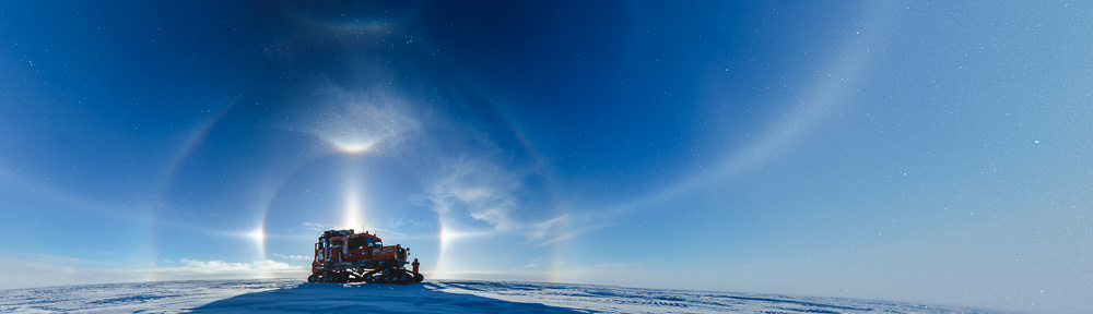
At that stage, the weather calmed down and we had some sunshine and blue skies. We quickly drove over the Gatekeeper crevasse and went further on, all the way to Aladin’s Cave, which is where we set up camp.

Panorama of our camp with the Aladin’s in the background
After setting up the camp, we made some tea and some food and went out for a walk. It was fairly cold, but we wrapped up nicely and just explored the area. We’ve seen the sunset which created some beautiful colours, took some pictures, and generally enjoyed the time out.

Al contemplating the view

Sunset

Dusk in Antarctica

Dusk in Antarctica

Dusk in Antarctica

Our home for the week
Tuesday
We woke up to a beautiful sunny day, with no wind at all. We decided to use the opportunity and skidoo further South-East, towards the continent.
First on the way was the Stony Berg, which is quite interesting in that it is the only place you can actually see rock in the area. The suspicion is that Stony Berg, when it calved thousands of years ago, must have tumbled over and scratched the sea bed, bringing the rocks, sand and silt to the surface. Quite cool!

On top of Stony Berg

Sitting on top of Stony Berg, looking down

Sitting on top of Stony Berg, looking down
We then proceeded even further South-East, towards the Pinnacle Berg and the Continent. After another hour or so of driving the skidoos, trying to find our way, going from one brow to the next, we finally arrived to a place we believed was just about 2km away from the main continent.

The Continent is that way!
Wednesday
Despite the original forecast, Wednesday turned out very quiet if a bit cold and overcast. We decided to stay local, and just explore the Aladin’s features nearby.
We roped up, gathered some climbing gear, and set out. After an initial abseil down, we went on with an idea of finding a wall we could climb or a crevasse we could descend into. Al’s skills, experience and sixth sense proved great, as he quickly found a virgin crevasse. I would never have spotted it, but he just asked us to stop, knelt down and punched some snow with his ice axe, which opened up this great crevasse we immediately called Al’s Crack! He asked who wants to go in and I couldn’t miss the opportunity.
This was true exploration in Antarctica — most likely I was the first human being to ever have set foot in that crevasse! How cool is that??

Inside a crevasse

Descending into a crevasse
After playing with the crevasse, we went back and explored the other side of the ice berg that makes the Aladin’s. We saw what looked like a frozen lake of blue ice (which it’s not, but it very much looks like one), with an ice wall made up of fish-scale like features on one side and a wall with some beautiful icicles, tunnels and overhangs on the other. If you told me such a place exists, I would have never believed it!

Standing on what I call a “frozen lake”

Ice formations

Fish scales
Thursday
After waking up and having some breakfast, we spent some time in the tent chatting, playing some cards, we went out again with the intention to do some ice climbing on the Aladin’s berg nearby.
We had a brilliant day — it was all exploration and the climbing was not really that difficult, but because we are really far away from anywhere (Halley Station feels like the centre of civilisation from the perspective of a little tent somewhere on the Ice Shelf), that was all fine. Also, we were climbing walls that possibly nobody has ever climbed before, and certainly there is no guides or documentation on them.

Ice climbing
Later in the day we went back to the “frozen lake” feature, to go through the tunnel created by some overhanging ice. It was spectacular, it was beautiful and neither the pictures nor my words can do it any justice at all.

Through the tunnel
Finally we went back to the tent for the final night of the trip.
The word we received over the HF radio during our scheduled comms was that the weather was meant to deteriorate and the wind was to pick up over night, although not quite as bad as it was originally predicted — only 15-18 knots were forecasted. We therefore braced for impact, got all the work that night that we could have done to prepare for the departure, and had a nice quiet night in the tent.

Home sweet home!
Friday
We woke up to a beautiful, sunny and really warm day — nothing like the forecast predicted! We packed the camp, mounted our trusted skidoos and went back towards the Gatekeeper and Halley, our home.
We still had one thing to do on the way back, which is to abseil into the Gatekeeper!

Abseiling into Gatekeeper
Abseiling into it gave us an opportunity to see the bridge we’ve just gone over on the skidoos from a very different perspective!

The bridge over Gatekeeper
We arrived to Halley safe and sound around 1600 on Friday, unpacked, had a long needed shower, some tea and some food.
Following is our full trip’s track as recorded by my trusty Garmin eTrex 20. Please note, that due to the constant ice movement of roughly 450m per year in West-North-West direction and the age of the satellite image (which I estimate to be from around 2009), there is an offset between the track and the features you’ll see on the map (the image is shifted to the East, i.e right on the map, compared to where the actual features currently are). Also, the ice doesn’t move uniformly — some areas of the ice sheet move faster than others.
[map style=”width: auto; height:400px; margin:20px 0px 20px 0px; border: 1px solid black;” maptype=satellite gpx=”http://antarcti.co/wp-content/uploads/sites/12/winter-trip-2014-02.GPX”]
Winter Trip Track
This was possibly one of my best trips ever and I’m already looking for the next one. Only eight months to go!
I’d like to use this opportunity to thank our Field Guide. Thanks a lot Al, I’ve learnt a lot from you on this trip and it was a privilege to be there with you!
Fantastyczna wyprawa i przygoda; tylko pozazdrościć. Super zdjęcia, szczególnie te ze szczeliny lodowej, tunelu i formacji lodu